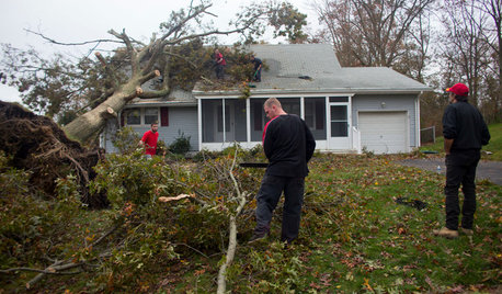
All week I have written about the flooding situation at the Red River which is approximately 1 mile from our home.
However, I know that rivers and creeks are flooding all over Oklahoma. In many cases, there is far more severe flooding elsewhere than what we are seeing here.
So, here's a synopsis of what is going on around the state in case you are interested. Some of the numbers are amazing. This info is based on National Weather Service data and will be obsolete even before I can finish typing this post, since rain continues to fall in many locations.
Since I can't (won't) go outside and work in the rain, I am going to have to do laundry and clean house. By spending time on this post, I delay those chores for another hour or so. lol
Seriously, though, this synopsis emphasizes just how many areas are facing flooding, and some of it will be quite severe.
I would guess there is not much gardening going on in Oklahoma right now.
Feel free to post your own comments regarding what is going on around you. I suspect that many of us would be surprised at how much high water different folks are encountering.
Dawn
ARKANSAS RIVER AT RALSTON:
Sat. a.m. Flood Stage (9 a.m.): 17.2'
Flood Stage: 16.0'
Minor flooding forecast, minor flooding occurring
Will crest near 17.6' early Sunday afternoon and fall below flood stage by Monday afternoon.
BEAVER CREEK NEAR WAURIKA IN SC OK:
Sat a.m. Flood Stage (5 a.m.): 29.1'
Flood Stage: 25'
Moderte flooding is occurring. Creek has already crested and will continue falling. Will be below flood stage around 1 a.m. Saturday.
BIRD CREEK AT AVANT:
Sat a.m. Flood Stage (8 a.m.): 18.7'
Flood Stage: 21'
Moderate flooding is forecast.
Creek will rise above flood stage late Sat. morning and crest near 21.3' Sat. afternoon and then fall below flood stage late Sat. afternoon.
BIRD CREEK NEAR SPERRY:
Sat a.m. Flood Stage (8 a.m.): 22.4'
Flood Stage: 21'
Will crest bear 27.4' early Sunday afternoon annd will fall below flood stage Monday morning.
BIRD CREEK BEAR OWASSO-MINGO:
Sat a.m. Flood Stage (8 a.m.): 15.9'
Flood Stage: 18'
Moderate flooding is forecast.
Will rise above flood stage early Sunday morning and crest near 20' Monday morning, falling below flood stage by Monday evening.
BLACK BEAR CREEK AT PAWNEE:
Sat a.m. Flood Stage (9 a.m.): 18.4'
Flood Stage: 17.0'
Minor flooding forecast and minor flooding occurring.
Crested on Friday at 20.3' and will fall below flood stage by dawn Sunday.
BLUE RIVER NEAR BLUE:
Sat a.m. Flood Stage (7 a.m.): 21.9'
Flood Stage: 24'
River will rise above flood stage around 9 a.m. Sunday and crest bear 24.2' around 1 p.m. Sunday, falling below flood stage around 7 p.m. Sunday.
Historical Comparison: Mar. 21, 1985--crest of 24.2'
CANEY RIVER AT BARTLESVILLE:
Sat a.m. Flood Stage (7 a.m.):14.2'
Flood Stage: 13'
Minor flooding is occurring and moderate flooding is forecast. Will crest near 18.3' Sat. evening and then begin falling.
***When the Caney River reaches 18' near Bartlesville, severe flooding will occur in Bartlesville and suburban areas.***
CANEY RIVER NEAR COLLINSVILLE:
Sat a.m. Flood Stage (9 a.m.): 25.6'
Flood Stage: 26'
Moderate flooding is forecast.
River will rise above flood stage late Sat. morning and crest near 32.9' Monday afternoon.
CANEY RIVER NEAR RAMONA:
Sat a.m. Flood Stage (8 a.m.): 25.6'
Flood Stage: 26'
River will rise above flood stage late this morning and crest near 28.1' on Sunday morning. Will fall below flood stage on Wednesday afternoon.
CIMARRON RIVER NEAR DOVER IN CEN OK:
Sat a.m. Flood Stage (4 a.m.): 20.4'
Flood Stage: 17'
Will crest at 20.5' Sat. a.m. and begin falling. Will fall below flood stage around 6 a.m. Monday.
CIMMARON RIVER NEAR GUTHRIE IN CEN OK:
Sat a.m. Flood Stage (4 a.m.): 13.6'
Flood Stage: 13'
Will continue rising and crest near 14.1' around 7 p.m. Saturday. Will fall below flood stage around 11 a.m. Sunday.
***AT 14' river levels reach bankfull levels or higher in Logan and Payne Counties and US hwy 77 north of Guthrie is impassable.***
Historical Comparison: May 24, 1938 crest of 14.1'
CIMMARON RIVER NEAR PERKINS IN CEN OK:
Sat a.m. Flood Stage (11 p.m.): 18.6'
Flood Stage: 17'
Minor flooding is occurring and moderate flooding is forecast.
River will continue rising an crest near 20.1' around 1 a.m. Sunday. It will fall below flood stage around 2 p.m. Monday.
***At 20', several hours before and after the crest, water overtops and may close U.S. Hwy 177 south of Perkins,***
CIMMARON RIVER NEAR OKEENE IN CEN OK:
Sat a.m. Flood Stage: Not Available
Flood Stage: 14'
The River has crested here and minor flooding is occurring.
Will fall below flood stage sometime Saturday morning.
Historical Comparison: May 19, 1949 crest of 20.2'
CLEAR BOGGY CREEK NEAR CANEY IN SE OK:
Sat a.m. Flood Stage (8 a.m.): 23.3'
Flood Stage: 19'
Moderate flooding is forecast and moderate flooding is occurring.
A broad crest is occuring. The creek is forecast to begin further rising Sat. afternoon and will crest around 24.3' around1 a.m. Sunday.
***At 24', many rural roads become impassable and bottomlands are flooeded in western Atoka County and the nor
COTTONWOOD CREEK AT GUTHRIE
Sat a.m. Flood Stage (4 a.m.): 20'
Flood Stage: 23'
Creek will crest at 23.6' around 1 p.m. Saturday and fall below flood stage by Saturday evening.
***At 24', Noble Ave. is closed to auto access from est to west where the hospital is located. Residential and business areas in town could suffer life-threatenin currents as could rural flood plains.**
COTTONWOOD CREEK NEAR SEWARD IN CEN OK
Sat a.m. Flood Stage (4 a.m.): 27'
Flood Stage: 25'
Minor flooding is forecast and minor flooding is occurring.
Will crest near 28.2' aroud 7 a.m. St. and will fall below flood stage by 5 p.m. Saturday.
Historical Comparison: Dec. 20, 1991 crest of 28.5'
DEEP FORK RIVER NEAR BEGGS:
Sat a.m. Flood Stage (8 a.m.): 25.7'
Flood Stage: 18'
Moderate flooding forecast and moderate flooding is occurring.
Will crest near 27.3' on Monday a.m. and then begin falling.
DEEP RED CREEK NEAR RANDLETT IN SW OK:
Sat a.m. Flood Stage (6 a.m.): 25.7'
Flood Stage: 20'
The Creek will continue rising and crest near 25.9' at 7 a.m. Saturday. Will fall below flood stage around 10 p.m. Monday.
Historical Comparison: Octo. 23, 1986 crst of 25.9'
EAST CACHE CREEK NEAR WALTERS IN SW OK:
Sat a.m. Flood Stage (5 a.m.): 28.6'
Flood Stage: 21'
Creek will continue rising and crest near 29.5' around 1 p.m. Sunday.
***At 30' valley-wide flooding of cropsland, pastures and local roads occurs in southern Comanche County and Cotton County, accompanied by flood depths up to 9' and very dangerous currents.***
KINGFISHER CREEK NEAR KINGFISHER IN CEN OK
Sat a.m. Flood Stage (5 a.m.): 20.8'
Flood Stage: 20'
Minor flooding is occurring. Creek is near crest and should begin falling by Saturday a.m.
LITTLE RIVER NEAR TECUMSEH:
Sat. a.m. Flood Stage (9 a.m.): 10.8'
Flood Stage: 11.0'
This river has crested three times this week, once on Tuesday and twice on Friday, with the highest stage being 15.93'. It has now receded below flood stage.
LITTLE RIVER NEAR TECUMSEH IN CEN OK:
Sat a.m. Flood Stage (4 a.m.): 12.6'
Flood Stage: 11'
River has crested and will continue falling. Will fall below flood stage by Saturday evening.
NEOSHO RIVER NEAR COMMERCE:
Sat a.m. Flood Stage (8 a.m.): 18.9'
Flood Stage: 15'
Moderate flooding was forecast and moderate flooding is occurring.
Will crest near 21.6' on Tuesday and then begin falling, but will remain above flood stage until Thursday.
NORTH CANADIAN RIVER NEAR HARRAH:
Sat a.m. Flood Stage (9 a.m.): 18'
Flood Stage:14'
Moderate flooding is forcast and major flooding is occurring. Currently near its crest.
Historical Comparison: Nov. 5, 1974 crested at 17.9'
NORTH CANADIAN RIVER NEAR OKC:
Sat a.m. Flood Stage (9 a.m.): 18.6'
Flood Stage: 12'
Minor flooding is occurring.
River has crested and will fall below flood stage around 7 p.m. Sunday.
NORTH CANADIAN RIVER NEAR YUKON:
Sat a.m. Flood Stage (8 a.m.): 14.8'
Flood Stage: 14'
Minor flooding is occuring.
River has crested and will fall below flood stage around 5 p.m. Saturday.
RED RIVER NEAR GAINSEVILLE, TX/THACXKERVILLE, OK:
Sat a.m. Flood Stage (5 a.m.): 29.5'
Flood Stage: 25'
River crested on Friday at 30' and is falling. River is forecast to rise again and crest near 29.7 feet on Monday a.m.
Historical Comparison: August 6, 1995 crest of 29.6'
SALT FORK ARKANSAS RIVER AT TONKAWA IN NE OK:
Sat a.m. Flood Stage (5 a.m.): 22.8'
Flood Stage: 17'
Will continue rising and crest near 23.7' around 7 a.m. Sunday. It will fall below flood stage around 6 p.m. Tuesday.
***AT 24' flood depths up to 7' can move from eastern Grant County across Kay County to the confluence with the Arkansas River below Ponca City. Some roads will be closed.***
Historical Comparison: October 5, 1959, crest of 23.5'
WASHITA RIVER AT ANADARKO IN SW OK:
Sat a.m. Flood Stage (2 a.m.): 21.6'
Flood Stage: 19'
River will crest near 21.8' Sat a. m.
***AT 22', campgrounds in Anadarko City Park and nearby low area are flooded. Floodwaters damage farm propery and blcok many rural roads along the river in eastern Caddo and western Grady counties.***
Historical Comparison: Oct. 22, 1965 crest of 21.8'
WASHITA RIVER NEAR CARNEGIE IN SW OKLAHOMA
Sat a.m. Flood Stage (3 a.m.): 23.3'
Flood Stage: 25'
RIver will rise above flood stage around 2 p.m. Sat. and crest near 26.7' around 1 p.m. Sunday. It will fall below flood stage around 11 a.m. Molnday.
***At 27', look for flooding of croplands and pastures along the river valley in easter Washita and western Caddo counties. More then 3000 acres of farm land are overtopped by flood depths of 2'. Local roads may be topped, isolating a few farmsteads.***
Historical Comparison: May 31, 1980 crest of 26.6'
WASHITA RIVER NEAR DICKSON IN SC OK
Sat a.m. Flood Stage (3 a.m.): 26.5'
Flood Stage: 27'
The Washita river will rise above flood stage around 6 a.m. Saturday and crest near 27.3' around 1 p.m. Sat. Will fall below flood stage around 8 a.m.
***AT 27' flood depths of 2' extend along the Washita River Valley in Murry, Carter and Johnston Counties. Over 3,000 acres of bottomlands between Rock Creek between Doughtery and Lake Texoma are now underwater.
Historical Comparison: April 12, 1967 crest of 27.3'.
WASHITA RIVER AT LINDSAY IN SC OK:
Sat a.m. Flood Stage (12 a.m.): 20.8'
Flood Stage: 18'
Moderate flooding is occurring. The river has crested at Lindsay and will fall below flood stage Saturday afternoon.
VERDIGRIS RIVER NEAR LENAPAH:
Sat a.m. Flood Stage (8 a.m.): 32.3'
Flood Stage: 30'
Moderate flooding is already occurring and major flooding is forecast. River will continue rising and will crest near 38' Sunday a.m. Will fall below flood stage by Tuesday afternon.
***At 38', EXTREME flooding will occur in Nowata County and many rural roads will be closed. State Hwy 10 east of Lenapah will be under several feet of water.
Historical Comparison: July 4, 1976, crest of 38.4'


susanlynne48
Okiedawn OK Zone 7Original Author
Related Discussions
River Birch
Q
What is your annual flood insurance premium?
Q
Anyone familiar with flood plain issues?
Q
building an Ark! the Houston flooding
Q
merryheart
katrina1
ilene_in_neok
Okiedawn OK Zone 7Original Author
susanlynne48
ilene_in_neok
Okiedawn OK Zone 7Original Author
susanlynne48
ilene_in_neok
susanlynne48
Okiedawn OK Zone 7Original Author