


Very High Fire Danger 1-22 and 1-23
Okiedawn OK Zone 7
14 years ago
Sort by:Oldest
Comments (6)
Related Stories

FEEL-GOOD HOME12 Very Useful Things I've Learned From Designers
These simple ideas can make life at home more efficient and enjoyable
Full Story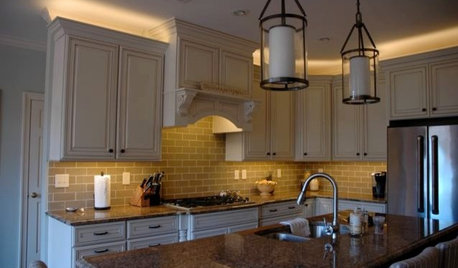
LIGHTINGThe Lowdown on High-Efficiency LED Lighting
Learn about LED tapes, ropes, pucks and more to create a flexible and energy-efficient lighting design that looks great
Full Story
PETSGarden Alert: 22 Plants to Keep Away From Pets
Avoid potential danger by keeping dogs and cats away from these landscaping and houseplant favorites
Full Story
KITCHEN COUNTERTOPSKitchen Counters: High-Tech Solid Surfaces Make Maintenance Easy
Sculpted by heat and nonporous by nature, solid-surface countertops bring imagination and low maintenance to the kitchen
Full Story
MOST POPULARHow High Should You Mount Your TV?
Today we look at an important question to consider when locating your television: How high should you set it?
Full Story
DECORATING GUIDESHow to Work With a High Ceiling
Learn how to use scale, structure and shapes to create a homey-feeling space below a grand ceiling
Full Story
GREEN BUILDINGMeet a High-Tech Home That Monitors Itself
Energy vampires have nowhere to hide in this LEED Platinum home, as energy efficient as it is architecturally beautiful
Full Story
ARTNew Digital Art Frame Gets Put to the Test
Our writer sets up the EO1 at home, then invites artist friends over for a look — at images of their own work. See what they have to say
Full Story
MOST POPULAREasy Green: 23 Ways to Reduce Waste at Home
Pick from this plethora of earth-friendly ideas to send less to the landfill and keep more money in your pocket
Full Story
DECORATING GUIDESPractical New Uses for 23 Old Things
Junk? What junk? Those things cluttering up your storage space are home solutions waiting to happen
Full Story
elkwc
Okiedawn OK Zone 7Original Author
Related Discussions
Fire Weather/Extreme Fire Danger
Q
Fri. 4-29, Dangerous Wind and High/Extreme Fire Danger
Q
Wed: High Wind,Critical Fire Danger, Snow, Dust
Q
SS Support Mon 1/23 to Sun 1/29
Q
owiebrain
elkwc
Okiedawn OK Zone 7Original Author
owiebrain