


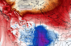
Whoa Alberta....weather models are a gift from a frozen over hell.
Plant Love
4 years ago
Featured Answer
Comments (234)

Plant Love
3 years agoPlant Love
3 years agoRelated Discussions
LG French Door Model# LFX25950ST
Comments (27)Patti - Yeah,... I haven't had a cube of ice out of this thing since they brought it in here last Tuesday. And I am kinda nervous, not so much with the model itself but more with the customer service I read about coming from LG. I did purchased the 4 year EW though, but I hear that's not that much better. footballmom - Yeah,... I am getting water out of the dispener, so I know the water line is attached and turned on. Nice call! Just no ice. I've even tried turning the icemaker off for a while, just in case the switch was reversed somehow (I've seeen that before on certian things),... no change. I can't get a clear look into the water cells to see if there's water actually in either of the six cells, can't hear whether water is filling up the cells eiher (this thing is so quite when closed). If water (by now ice) is in those cells, then it's got to be a problem with the mechanism. I took some ice out of the fridge under the wet-bar in the basement and put it in the LG bucket to ses if the auger worked and ice would fall out of the dispenser,... it works well and the cubes fell. But it's not making ice on it's own. HD says it maybe because of the delivery damage, but I can't see those bumps causing this,... I wouldn't think this thing is that tender! Im' just on the fence as to accept another 950 or add a few bucks and have them bring out a 960. Upside,... I hear I'll be getting a newer model with a few more features and some problems worked out (Patti, I hear the food freezing in the crisper thing was fixed with the 960 by way of their newly designed drawers). Downside,... I'll be getting a unit not as aesthetically pleasing (I like the gray case and trim better than the black). Hell,... I guess I could always spend way more than we budgeted and opt for the 980. Yeah right,... I'd then be updating you good folks on how I made out in divorce court. LOL!...See MoreChristmas gifts.
Comments (47)I've started shopping already-- which is pretty unusual for me. It's not a concentrated effort but I found a few things that were perfect for some of the people on my list and I decided not to hesitate or wait to see if I found something better. The truth is, I think the best gifts are those that make you THINK of them as soon as you see them. One of my sisters loves adult coloring books as a stress reliever-- she loved them even before they were hot. I found this lovely hardbound Swedish adult coloring book Summer Nights. I am very pleased with it--it's very gift-worthy as coloring books go. I am also planning to put together a "funky veg" seed package gift for a niece who this year had her first garden. She tells me "funky" is her second favorite F-word (we DO share that in common!) so this caught my eye. I suspect this kit has been on the shelf at amazon for awhile as they are sold out in most stores here in the US. I think I will put together my own using heirloom seeds. Another small gift that was a hit with the 20somethings.. cappuccino stencils. I kept getting text messages with shots of their homemade lattes/cappuccinos. You could make a more substantial gift by adding espresso beans, a cocoa shaker and a milk frother-- or just the stencils make a great stocking stuffer!...See MoreFood items to send as gift ideas pls
Comments (34)One thing I traditionally get for my DD and son in law are the annual passes to our state and local parks because they love to hike and enjoy the many lakes they have. (Michigan has over a million w/in it’s borders) One of the larger sports/hunting stores in their area, Bass, Cabella’s or the likes is an easy place to find out what the state he’s in requires and where you can buy them from; often times they sell them right there. Also a gift certificate to one of those stores, Bass Pro’s especially would be great because they can buy whatever they need when they need it, whether it’s clothing or boots, new equipment or outdoors cooking “stuff” Bass has it all. Magazine subscriptions are good too, I have a sister who gets us annual renewals to our favorites and we love it. If they’re up north, they’re in doors all winter, how about a years subscription to Netflix or a streaming device like a Roku? You could also put together a winter basket with a variety of things that one never has too much of in winter. Wool smart socks, new hats, beef jerky or sausage, a cook book with new out door recipes or stews and soups, a safety beacon (mentioned above), a couple of fun or corny kitchen gadgets for when she’s canning. Things like that....See MoreJanuary 2018, Week 3, The Weather Strikes Back.......
Comments (125)I've typed and submitted the Week 4 thread twice today and when I hit submit it just disappears into outer space. I wonder where it goes? So, I'm going to try again, with only the word test, rather than typing everything and losing it again. I think I'll change the Subject line too in case the system is having a hard time telling week 3 from week 4. Rebecca, In Texas in zone 8, we only could grow tulips as annuals, though I sometimes had them come back for a couple of years. I planted them here anyway when we moved here, hoping that being further a little bit further north would help them live longer. It really didn't, although they came back every year--sort of. The second year most came back, and then less of them in the 3rd and succeeding years until there were none left at all. I love tulips, but don't bother with them any more. The warming climate worries me too for the sake of earth and all its flora and fauna. I had big plans for working outdoors today, but the wind has been gusting more than 10 mph higher than it was forecast to gust, and the things I want to do are not something that can be done easily with wind gusts at 40+ mph, so I ditched those plans. Tim's flu has relapsed and he is upstairs sick in bed with aches, pains and a very sore throat. (I told him he went back to work too quickly after only staying home for two days last week, and now he agrees with me.) Wow, we had great plans for this day in the bright, sunny early morning hour just after sunrise when it was fairly calm, mostly clear and 61 degrees. Then the clouds and wind rolled in and everything just fell apart. Today's weather now looks better on paper than it feels in real life, if that makes sense. Nancy, Think of what you and I could do if we didn't have all those pesky deer! And, for Rebecca, it may be the same---only with the squirrels. If they come back this year, I imagine the war is on, though I am not sure how you can war with squirrels within a proper city---out here in the sticks, people just shoot them if they must. Dawn...See MorePlant Love
3 years ago
L Clark (zone 4 WY)
3 years agoPlant Love
3 years agoPlant Love
3 years agoPlant Love
3 years agoPlant Love
3 years agoL Clark (zone 4 WY)
3 years agolast modified: 3 years agoPlant Love
3 years agoPlant Love
3 years agoL Clark (zone 4 WY)
3 years agolast modified: 3 years agoPlant Love
3 years agoL Clark (zone 4 WY)
3 years agolast modified: 3 years agoPlant Love
3 years agolast modified: 3 years agoPlant Love
3 years agolast modified: 3 years agoPlant Love
3 years agoPlant Love
3 years agoL Clark (zone 4 WY)
3 years agolast modified: 3 years agoL Clark (zone 4 WY)
3 years agoPlant Love
3 years agoPlant Love
3 years agoPlant Love
3 years agoPlant Love
3 years agoPlant Love
3 years ago
FrozeBudd_z3/4
3 years agoPlant Love
3 years agoPlant Love
3 years agoPlant Love
3 years agoFrozeBudd_z3/4
3 years agoL Clark (zone 4 WY)
3 years agoPlant Love
3 years agoFrozeBudd_z3/4
3 years agolast modified: 3 years agoFrozeBudd_z3/4
3 years agolast modified: 3 years agoPlant Love
3 years agoFrozeBudd_z3/4
3 years agoFrozeBudd_z3/4
3 years agowayne
3 years agoFrozeBudd_z3/4
3 years agolast modified: 3 years agoUser
3 years agoFrozeBudd_z3/4
3 years agoL Clark (zone 4 WY)
3 years agolast modified: 3 years agoFrozeBudd_z3/4
3 years agolast modified: 3 years agoFrozeBudd_z3/4
3 years agoFrozeBudd_z3/4
3 years agolast modified: 3 years agoPlant Love
3 years agoL Clark (zone 4 WY)
3 years agoFrozeBudd_z3/4
3 years agolast modified: 3 years agoFrozeBudd_z3/4
3 years agoUser
3 years agolast modified: 3 years ago


Related Stories
DECORATING GUIDESFrom Queasy Colors to Killer Tables: Your Worst Decorating Mistakes
Houzzers spill the beans about buying blunders, painting problems and DIY disasters
Full Story
KITCHEN DESIGN20 Kitchen Must-Haves From Houzz Readers
We asked you to tell us your top kitchen amenities. See what popular kitchen features made the list
Full Story
HEALTHY HOME6 Tips From a Nearly Zero-Waste Home
Lower your trash output and increase your quality of life with these ideas from a mom who did it to the max
Full Story
KITCHEN DESIGN16 Practical Ideas to Borrow From Professional Kitchens
Restaurant kitchens are designed to function efficiently and safely. Why not adopt some of their tricks in your own home?
Full Story
LIFEStop the Toy Takeover by Changing the Way You Think
Make over your approach and get gift givers onboard with your decluttering efforts by providing meaningful toy alternatives
Full Story
MOST POPULARModern Party Etiquette for Hosts and Guests
Learn the mannerly way to handle invitations, gifts and even mishaps for a party that's memorable for the right reasons
Full Story

MOST POPULAR11 Reasons to Paint Your Interior Doors Black
Brush on some ebony paint and turn a dull doorway into a model of drop-dead sophistication
Full Story
REMODELING GUIDESYou Won't Believe What These Homeowners Found in Their Walls
From the banal to the downright bizarre, these uncovered artifacts may get you wondering what may be hidden in your own home
Full Story
LIFE10 Ways to Cope With Grief During the Holidays
If you are experiencing loss, take it from an experienced griever — life has changed forever, but it does get better
Full StorySponsored
FrozeBudd_z3/4