


Bizarre North American Weather and You
tom1328732
7 years ago
last modified: 7 years ago
Featured Answer
Sort by:Oldest
Comments (15)
Related Discussions
What are your losses this bizarre year?
Comments (18)Looks like a Valencia orange is declining, after bearing profusely for almost 10 or more years. Never at a lack of nice orange juice in the morning. The juice is still fine, but the peeling looks almost burned and hard. Not sure what it is. The new growth looks fine, but the fruit doesn't mature to full size. On the bright side, the grapes produced well, except for a Chardonnay wine grape - which doesn't seem to like the foggy humidity. I'll give it another year - it is growing on an arbor that gets lots of heat and reflected heat as well. This is the first summer for good tomato growth. We are in the midst of a heat wave now - and they are thriving. Sooo - you lose some, win some. The persimmon produced maybe one or two, whereas last year it gave a good bounty. Go figure! bejay...See MoreNorth American vs European rose hybridisers
Comments (50)I had a point somewhere when I started that thread on this subject which I can't find now. So I'll settle on Cactus Joe's thread. Anyway I came across an article on Kordes in my old Rosebank news letters. It was an article by Harry McGee in September, 1995. The occasion was a visit to Canada by Wilhelm III. It has a good history of the Kordes firm. It started with Wilhelm the first in 1890 in Hamburg. Wilhelm II joined in 1919 in Sparrieshoop. He was succeeded by a non-Wilhelm but still a Kordes, Reimer. Then came the III. All were in charge of breeding operations. Other family members ran the business side. What is relevant in all of this is that the hybridizer was preminent in the firm and therefore put emphasis on that. At that time Kordes was the largest rose nursery in the world selling 2 million roses a year. They made 50,000 crosses a year. After a rose is singled out as a prospect it is grown for 6 or 7 years of testing before it is introduced. They probably are still the largest. Possibly the odds of creating a superior rose are in favor of those who do the most crosses. Stands to reason doesn't it? Even just blind choice should produce now and then something of value. One thing Mr. Kordes said that was interesting is that many breeders have stopped breeding HT's. One reason is that fewer people go to exhibitions. The other is that they are more difficult to get anything worthwhile. Hard to make disease resistant, many are single, fragrance is rare, have fewer hips and what they have don't germinate well and finally they produce fewer flowers. The emphasis on disease resistance began as a result of the Green Parties efforts to ban spraying in many parts of Germany. Kordes then stopped spraying. The result was disaster. Their fields became nearly barren of roses. I guess things have improved since then....See MoreWhat will this bizarre winter do to our gardens?
Comments (27)Here are some stats: Snowfall: Up to March 12th, Concord NH has had 51.8 inches of snow, a mere 3 inches below normal. Portland Maine has recorded only 37 inches, a full 19 inches below normal. In southern New England, Boston, Providence, and Hartford have recorded 30-36 inches of snow. That is almost exactly normal for Boston and Providence, but 9 inches below normal for Hartford. Temperatures: In southern New England, Boston, Providence, and Hartford have had mean temperatures from Dec-Feb that are about 1 degree above normal for the period. December was slightly cooler than normal and February was about 2 degrees warmer than normal. Up north, the temperature departures have been more extreme. Concord and Portland were not far from normal for December, but about 6 degrees above normal for February. And way up north, Caribou Maine has been running about 10 degrees warmer than normal all winter. So, yes, it has been a normal winter in southern New England. But it has been unusually warm further north, particularly in Maine (warmer than normal, but not warmer than southern New England). This trend of warm departures in far northern Maine to very cold departures in the Mid-Atlantic and Southeastern USA has created some topsy turvy temperatures. Boston, and most locations in coastal southern New England have had the same mean temperature for February as places like Washington DC and Roanoke Virginia, and WARMER than places like Baltimore and the suburbs of DC. I think from my perspective down here on the south coast, it has been the lack of extreme temperatures (warm or cold) that was noteworthy. It is normal for us to have no snow on the ground for most of the time in winter. But this year, plants have had no problem because of the lack of extremes, particularly at night. For February, I recorded my highest average minimum temperature for February since I started keeping records for my yard back in the late 90's.But my average maximum temperature was slightly cooler than normal. It will be a long time before we experience a winter like this again, particularly in Maine. Finally, Carl, why do you call yourself a "Yankee in exile"? You live in New Jersey. New Jersey is part of the northeast. You are still a Yankee (as commonly defined). One of your sports teams is called the Yankees. So relax. Your zip-code has changed but you are still one of us!...See MoreCrazy weather. Does this happen where you live?
Comments (33)The melting has started. All the snow at my house it gone. Green grass in the yard. The stories of those who died or were stuck in cars really bother me. For Christmas I'm making up emergency boxes for the family. Each one is getting one of those hammers that will break car glass. gsciencechick, if you are familiar with the Galleria Mall, a friend and I went on Friday night. The mall was open and hardly anyone there which was a very weird sight as this a busy entertainment complex in our area especially at this time of year. Some stores were closed, other had limited staff but they were so happy to see customers I got an extra 35% off at one store. It was kinda of weird to be shopping when so many were struggling to get out of their homes, etc. but there are still driving bans in the hard hit areas. Apparently all this crazy lake effect weather is due to a Typhoon near Asia pushed the jet stream out of whack....See More
tom1328732
7 years agolast modified: 7 years ago
hobbyartisan (Saskatoon, SK Canada, 2b)
7 years agotom1328732 thanked hobbyartisan (Saskatoon, SK Canada, 2b)tom1328732
7 years ago
Related Stories
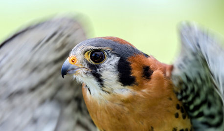
GARDENING GUIDESBackyard Birds: Create a Home for American Kestrels
These copper-colored birds of prey can be found throughout North and South America and often find habitats near human activity
Full Story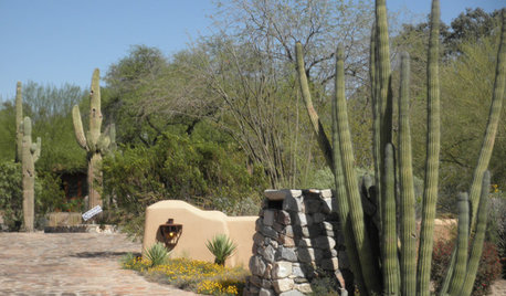
SOUTHWEST GARDENINGUnderstanding the American Southwest's Three Main Climate Zones
If you live in one of the arid or semiarid regions of the U.S. Southwest, this gardening zone guide is for you
Full Story
GARDENING GUIDESBackyard Birds: How to Care for American Goldfinches
The American goldfinch is a bright-in-the-summer visitor and one of the only vegetarian songbirds. Here's how to give them a healthy habitat
Full Story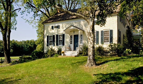
ARCHITECTURETimeline of American House Styles
Inspired by the Super Bowl commercials, a visual narrative of American home design
Full Story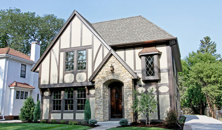
ROOTS OF STYLERoots of Style: The Indelible Charm of American Tudors
Rich details and an intimate scale give this English-inspired architectural style memorable character and flexibilty
Full Story
MOST POPULARHow to Hang the American Flag at Home
We’ll show you how to display the American flag on your house for Memorial Day, the Fourth of July or all year round
Full Story
DECORATING GUIDESSo Your Style Is: American Gothic
If Puritan with a touch of glam is pure style heaven to you, let the painting that started it all be your guiding light
Full Story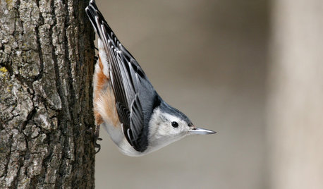
GARDENING FOR BIRDSBackyard Birds: Those Nutty Nuthatches
The North American songbirds, which often perch upside down, make themselves known in the winter landscape
Full Story
FLOWERS AND PLANTSHydrangea Arborescens Illuminates Garden Borders and Paths
This long-blooming eastern North American native shrub finds a home in landscapes around the world
Full Story
GARDENING GUIDESGreat Design Plant: Jeffersonia Diphylla
The long-lasting foliage of this eastern North American native excels at filling in a shady garden
Full Story
poncirusguy6b452xx